gtag('consent', 'update', {'ad_user_data': 'granted','ad_personalization': 'granted','ad_storage': 'granted','analytics_storage': 'granted' });
A A A
en
NL EN DE
Fotolux_Hanzestad_deel_1_19-09-2025_LR_07
Fotolux_Hanzestad_deel_1_19-09-2025_LR_05
Bommelse Brocante
koopzondag-1771335579

Route Zacharias

4.5 kilometers 2 hours
Walk along with Zacharias, a porter who lived in Zaltbommel in 1604. During the Hanseatic period, porters carried bales, barrels and crates for the merchants who made the city wealthy. Hard work in the heart of a thriving trading city. The walk passes by the imposing City Castle of Maarten van Rossum, the place where Zacharias presumably lived on the Nonnenstraat, medieval warehouses in the Ruiterstraat and fine Hanseatic period buildings on the Gasthuisstraat and the Markt.

Directions

1
Waterpoort — Start of the walk Waterpoort
In the first half of the fourteenth century, a system of city defenses—consisting of a city wall and a moat—was constructed in Zaltbommel. The town once had five city gates: the Gamerschepoort, the Bosschepoort, the Oenselsepoort, the Steigerpoort, and the Waterpoort; the latter is the only one that remains. The Waterpoort was restored in 1942–1943, acquiring its current appearance (without a layer of plaster). The reason the gate was preserved is not easily explained, but it may be linked to the fact that occupied houses had been built against its inner side.

Walk through the Waterpoort and immediately turn right—passing the terrace—onto Korte Tolstraat.
2
Korte Tolstraat 33 — Golden ship on the roof Korte Tolstraat 33
Atop the roof of the second house on the right, a beautiful golden ship can be seen—one that could pass for a Hanseatic ship (cog).
3
Korte Tolstraat 17/19 — Hanseatic-era houses Korte Tolstraat 17/19
The buildings on the right—numbers 17 and 19—date back to the Hanseatic era. Number 19 actually predates 1524, the year a city fire reduced a large part of Bommel to ashes.
4
Korte Tolstraat 8 – Sackendraegersgilthuys Korte Tolstraat 8
The Sackendraegersgilthuys (Sack-Carriers' Guild House) once stood on this site. Two stone houses stood here from 1350 onwards; they were combined in 1524. A source from 1639 identifies the building as the Sackendraegersgilthuys—the guild house of the sack carriers.

We turn left and walk onto Tolstraat.
5
Tolstraat — Water Pump Tolstraat
There is a water pump on the left. Like paved roads and brick houses, Zaltbommel had good water facilities. Compared to other cities, there were many water pumps in the town.

We turn right onto Gamerschestraat.
6
Gamerschestraat 16/24 — Hanseatic architectural style Gamerschestraat 16-24
Take a good look at the houses on the left side of Gamerschestraat. The second building (to the right of the corner building) features ornaments from the Hanseatic era. The type of brick used is also characteristic of the architectural style of that period; the bricks are larger than modern ones. The arches above the windows are likewise typical of the late Hanseatic era. The two buildings to the right of the arched façade still retain their original Hanseatic-era roof structure, with the roof running parallel to the street.

Keep walking on this side so we can get a good view of the façades across the street. At numbers 16–24, we can see many architectural features from the Hanseatic era. Here, too, the roofs run parallel to the street (the building line)—a common construction method at the time. This approach saved on building materials and created a great deal of (storage) space.

Between numbers 22 and 24 (near the lamppost), you can see a stepped fire wall, installed for fire safety reasons. The building at Gamerschestraat 24 dates back to the fourteenth century and was already constructed (at least partially) of stone.

We turn left and walk into the wide Karstraat, passing beautiful white-plastered buildings.
7
Karstraat 32/36 — Medieval plots Karstraat 32-36
The roofs of Karstraat 32–36 run parallel to the building line, just as we saw on Gamerschestraat. The medieval plot layout has remained intact. In the Hanseatic era, this was considered a wide street; cart drivers could easily pass one another, and even when carts were parked at the side, there was still plenty of room for other road users.

We continue straight ahead along Karstraat and cross Nonnenstraat to enter Oliemolen.
8
Oliemolen — Demolished oil mill Oliemolen
Oliemolen—the name says it all: a mill once stood here. Many mills stood in Zaltbommel—on the edge of town, atop the city walls, and outside the city itself. Marycken the miller’s wife loves to share more about this during a different walk. We continue our journey with Zacharias.
9
Oliemolen 2 — Beautiful property Oliemolen 2
Oliemolen 2 is a beautiful, atmospheric building. It is a remnant of a former monastery complex—hence the name *Nonnenstraat* (Nuns' Street), which we just crossed. To the left, we see a lovely wall reinforced with buttresses. Judging by the size of the stones, it is an old wall; the larger the stones, the older the structure. Beyond the wall, Oliemolen continues as a beautiful walking path.

Follow the path towards the *Heemtuin* (native plant garden).
10
Native Plant Garden — Mispelhof and Kloosterhof Heemtuin Mispelhof
To the left of the hedge lies the Mispelhof native plant garden, named after the medlar blossoms in the Bommel coat of arms. To the right of the hedge is the Kloosterhof native plant garden. Both gardens serve as reminders of the monastic life that once existed here.
11
The Gardens — Old Jewish Cemetery Singelwal
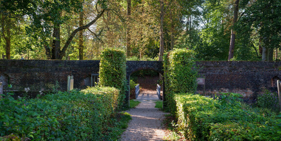
An old Jewish burial mound, situated against the city wall, is visible through a small gate on the right. Jewish people settled in Zaltbommel as early as the Hanseatic period. Like most Hanseatic cities, the town maintained a reasonably tolerant policy towards newcomers.

We continue along the path past the Jewish burial mound located behind the wall. Cross the water via the bridge on the left to reach the Singelwal. Then, turn left onto Boschstraat.
12
Behind the Wall — Old Cemetery Singelwal
Behind the fourteenth-century city wall lies an old Jewish burial mound. Jewish residents of Bommel were buried here until 1734. The Old General Cemetery and the older Jewish cemetery—which dates from a later period—are also located on Boschstraat.
13
Boschstraat — Bosschepoort Boschstraat
We pass the site where the Bosschepoort stood during the Hanseatic era. Like all the city gates, the Bosschepoort was a defining feature of the city. And, like so many others, this gate did not escape demolition; it gradually disappeared from the streetscape. In 1832, both the main gate and the outer gate still appeared on the map. Ultimately, the gate vanished in 1861.

Turn left onto Nonnenstraat.
14
City Castle — Maarten van Rossum House Nonnenstraat
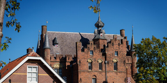
On the left, we see the *Stadskasteel* (Town Castle), commissioned by Maarten van Rossum (1495–1555). Maarten was a military commander by profession—though some sources describe him as a robber baron. In any case, his career paid off handsomely, bringing him great wealth. In 1534, the Duke of Guelders granted him the fiefdom of Bredevoort Castle, a position that required his personal presence. Since Maarten also held estates in the Bommelerwaard region, he appointed a steward to manage his ancestral seat, Poederoijen Castle. However, its proximity to hostile Brabant eventually made the location too dangerous for him. To safeguard his assets and income, he had this house built in Bommel for his steward—safely within the city walls and close to the town mansion of his brother, Johan van Rossum (at Kerkplein 16).

Maarten van Rossum’s house—the *Stadskasteel*—is medieval in origin but was remarkably modern for its time. Maarten commissioned highly innovative sculptural decorations; art historians now regard these ornaments as one of the earliest examples of Renaissance style in the Northern Netherlands. The arches and decorative elements are crafted from marlstone. In 1599, Johan van Oldenbarnevelt even visited the house to attend meetings. Although the building has been continuously inhabited, by the nineteenth century it had fallen into such disrepair that the owner at the time could no longer even use it to store potatoes, seeds, and onions. Today, it houses an engaging museum.
15
Nonnenstraat 22/28 — Residence of Zacharias Nonnenstraat 22-28
Across the street from Maarten van Rossum’s house, a sack carrier lived on Nonnenstraat in 1604.

Five so-called *cameren*—rental dwellings for single-person households—stood on this site. There were other such units in Zaltbommel, often built by wealthy merchants or institutions for rental purposes. In Zaltbommel, social classes and population groups did not live in segregated neighborhoods; Maarten van Rossum’s house—though he was rarely there—was situated opposite that of a sack carrier. A single street might be home to a distinguished official, a wealthy merchant, and a sack carrier like our Zacharias.

The sack carrier living here paid an annual rent of eighteen guilders to the civic orphanage, which had commissioned the construction of the five small houses. Water was easily accessible to the sack carrier, as there was a pump on Nonnenstraat. According to tradition, cooking was done behind the house under a small lean-to for reasons of fire safety.

We leave Zacharias’s house and continue walking, turning right onto Oliestraat. At number 41 stands a distinctive building featuring beautiful small arches—an architectural detail dating back to the Hanseatic era. Then, turn right onto Spiesmakerstraat, which leads into Ruiterstraat.
16
Ruiterstraat 8/14/16/18 — Hanseatic-era houses Ruiterstraat
Ruiterstraat 8 is a distinctive building; that is evident at a glance. It is an old Hanseatic-era warehouse that dates back to the fourteenth century. Goods such as grain and wool were once stacked here.

Ruiterstraat 14 is a beautiful house dating from 1630. Another house stood on the site around 1540. With its natural stone bands, stepped gable, and spacious front garden, the property has a striking appearance.

Next door, Ruiterstraat 16 is equally magnificent. The large bricks suggest medieval origins; the building dates back to the Hanseatic era.

At Ruiterstraat 18, we can see that the façade leans slightly forward. This was a deliberate design choice known as "building with a forward lean" (*op de vlucht*). This construction method was frequently used during the Hanseatic era. Although it might not look like it, building with a forward lean actually made the structure much stronger. This building dates from 1632, though its origins are older.

We continue straight ahead and cross the street. Korte Strikstraat is to the left and Lange Strikstraat is to the right; we walk straight on to the T-junction and turn right onto Kerkstraat. Jan Trip’s house stands on the corner to the right; he will gladly tell you more about it during his walking tour. We turn left onto Oenselstraat.
17
Oenselsestraat 17/32 — Hanseatic features Oenselsestraat
On the left-hand corner, at Oenselsestraat 17, stands a stately building featuring many characteristics of the Hanseatic era. Inside, there is a *hangkamer*—a type of open mezzanine. This arrangement gave the house two levels while still allowing ample light to enter through the windows in the façade. The arches and the ornamentation beneath them, along with the white bands—known as *speklagen* (alternating brick and stone courses)—are recognizable as typical architectural features of the Hanseatic period.

The building diagonally opposite, at Oenselsestraat 32, was also built during the Hanseatic era. We can see that the façade is built with a forward lean (or 'jetty').

We turn left onto Maasstraat and then left again onto Heilige Geeststraat.
18
Heilige Geeststraat 23 — Urban farm Heilige Geeststraat 23
This street used to be called Vollerstraat. This is a place Zacharias needed to visit; it was where the *vollers*—the wool processors—worked. Wool was felted here to produce *karsei*, the highly sought-after fabric from Bommel that was traded in many Hanseatic cities.

Immediately to the right is 23 Heilige Geeststraat. During the Hanseatic era, this building served as a storage shed or warehouse. Take a close look at the façade (which was added after the Hanseatic period); it makes the building appear larger than it actually is.

We turn right onto Kerkstraat and then immediately left past the bollards onto Vismarkt.
19
Gasthuisstraat — Buildings from the Hanseatic era Gasthuisstraat
We pass the tower of the Gasthuiskapel (Hospital Chapel) and the Gasthuis (Hospital) itself—two distinctive buildings in Bommel. The former *Groote Bommelsche Gasthuis* is a complex of buildings that evolved from the fourteenth century onwards, situated between Kerkstraat, Vismarkt, Oude Vismarkt, and Gasthuisstraat. The oldest surviving section is the former hospital chapel at Gasthuisstraat 34. The original hall church—possibly dating back to the fifteenth century—was plastered and underwent extensive alterations during the nineteenth and twentieth centuries. Its wooden barrel vault and roof structure date from the first half of the sixteenth century.

The Gasthuistoren (Oude Vismarkt 1)—which was not formally part of the hospital's property—is an unarticulated square tower featuring a stair turret and a constricted spire topped by a pear-shaped finial and an open lantern. The tower dates largely from the second half of the fifteenth century, while the crowning structure dates from around 1530. Housed within the lantern are an hour-striking bell by Jasper Moer (1533) and a carillon by Pieter and François Hemony (1654). An equestrian figure mechanism—likely dating from the seventeenth century—is visible on the west façade.

We turn left onto Gasthuisstraat.

We see Gasthuisstraat 22, a white-plastered building from 1550. The three arches above the windows are an architectural feature characteristic of the late Hanseatic era.
Next to it stands Gasthuisstraat 24; this building features a *hangkamer* (an upper-floor room projecting over the street). The façade displays further architectural styles from the Hanseatic period: the brickwork, arches above the windows, bands of white stone, shutters, and stepped gable all evoke a genuine Hanseatic atmosphere. Across the street stands Gasthuisstraat 23. The façade has a nineteenth-century appearance, as do the wall anchors, yet we see beautiful arches above the windows—an architectural feature from the Hanseatic era.

The building at Gasthuisstraat 17 dates from 1605 and features a jettied design (built with an overhang). Can we recognize the architectural styles of the Hanseatic era? Brickwork, white banding, and arches above the windows finished with an ornament. The bricks at the top are larger than those on the ground floor. It appears the façade has been altered over the centuries.

Gasthuisstraat 4-2 looks nineteenth-century but dates from 1535; it was a private residence during the Hanseatic era.

Continuing straight ahead, we reach the Markt.
20
Markt 1/2/3/6 — Historic buildings Markt
At the intersection leading to the Market Square, we see many buildings bearing traces of the Hanseatic era:

On the right, at the corner of Gasthuisstraat and Waterstraat, we see a *pothuis* (a projecting ground-floor extension) at Waterstraat 2. In the Middle Ages, there were far more of these structures than there are today. A *pothuis* is a small extension built over a cellar that served as a workspace without blocking light from the main house. As traffic increased, these curious structures became a hindrance, leading to the demolition of many of them.

The building diagonally opposite (on the corner with Boschstraat) also features one of these fine *pothuis* extensions. It is remarkable to find two such structures so close together in this city!

The building at Markt 1 (on the corner of the Market Square and Boschstraat) features a *hangkamer* (suspended room) dating back to the Hanseatic era. This type of construction is found in many houses in Zaltbommel. It consists of a mezzanine level—originally set slightly back from the front façade—positioned above the hearth. This created an additional room that did not require separate heating, while light entered through the windows. It was an efficient way to create more space while ensuring sufficient natural light.

The building next door (Markt 3) has a striking pillar in its façade, situated between the upper-floor windows. During the Hanseatic era, it served as both a home and a workplace. The façade clearly dates back to that period. The distinctive pillar between the upper windows is a characteristic feature of the Renaissance, the architectural style that was popular here at the end of the Middle Ages.

The building across the street—located on the corner of the Market Square and Waterstraat—is a real eye-catcher. It is a beautiful structure, complete with a *pothuis*, a stepped gable, and shutters. It is one of the earliest stone buildings in Bommel and the best-preserved one. It was used as a residence in the thirteenth century. Later, during the Hanseatic era, it housed a trading firm. The shutters on the Waterstraat side, when opened, served as sunshades. The shutters beneath the windows could also be folded up to serve as a counter.

The building in the same row, at Markt 6, features a mezzanine level. The gable stone bears the inscription ‘De Blauwe Fles’ (The Blue Bottle). Although the date 1644 appears on the façade, the building is much older, with origins dating back to the Hanseatic era. During that time, it served both residential and commercial purposes—just as it does today.

Walk back and turn left onto Waterstraat.
21
Waterstraat 26 — Colorful building Waterstraat 26
Waterstraat 26 stands out due to its color; it is a remarkable building.
It is frequently cited as a significant example of Renaissance architecture in the Low Countries. While the roof structure dates back to 1540, the size of the bricks suggests that some of the walls are considerably older, pointing to a date of origin in the first half of the fifteenth century. Archaeologists discovered a deep wharf-like structure in the cellar. The theory is that the building could be reached by boat from the Waal River—though it remains just that: a theory.

The natural stone carvings and architectural elements date from the sixteenth century, and researchers wonder if the ornaments originated from the home of Johan van Rossum (Maarten’s brother), who owned the house at Kerkplein 16. Over the centuries, the building has undergone numerous alterations, renovations, and modifications to become what it is today.

Finally, we arrive at the Waterpoort—the end of the walk. Zacharias turns left onto Korte Tolstraat, heading toward the Sack Carriers' Guildhall. Let’s see if he can pick up some extra work unloading a shipment.
Wandelroute Zacharias